Private Offering · San Jerónimo Corridor, Chihuahua · Santa Teresa Border Region

La Joya — own the ground North America’s next supply chain runs through

2,955
Acres (1,196 ha)
6.5 km
To the U.S. border
~7 mi
To the port · water on-site
The Opportunity

Nearshoring needs land. Here are 2,955 acres of it.

2,955 flat acres in San Jerónimo, 6.5 km south of the U.S. border, in the corridor Mexico chose for its new San Jerónimo development zone. El Paso and Juárez are running out of room — the growth is moving here: new plants, rail, a $165B AI campus and an expanding port.

Park-scale land for industry, logistics or a master plan. Water on site (JMAS pumping plant and wells 9 & 10), flat terrain with service roads in place, and an uncongested crossing versus the El Paso–Juárez bridges.
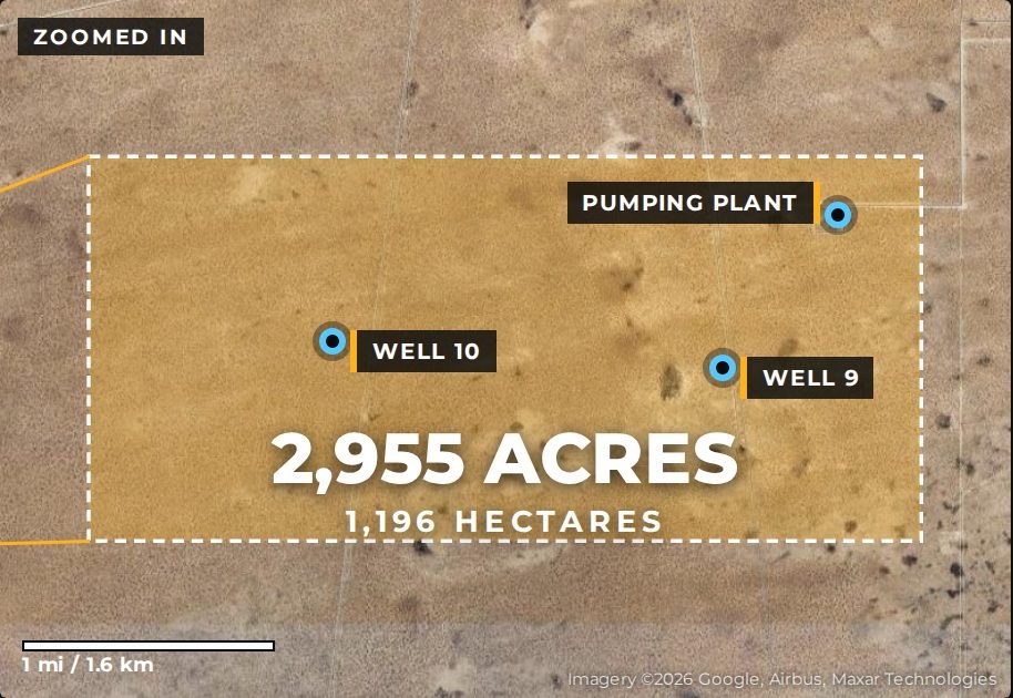
La Joya: 2,955 acres, 1,196 hectares, with on-site pumping plant and wells 9 and 10
Size & Setting

2,955 acres, in context

4.6

Square miles

About 3.3 × 1.4 miles (5.3 × 2.2 km) — roughly 2,200 football fields, larger than Union Pacific’s entire 2,200-acre rail yard.

6

Miles to Foxconn

The world’s largest electronics manufacturer is next door: a 2.7M SF campus, in the state of Chihuahua since 2009 with $500M+ invested.

#6

Port by trade

The Santa Teresa–San Jerónimo crossing ranks among the top U.S.–Mexico ports, with ~80 companies in four Santa Teresa parks.
Location

Where two countries and three states meet

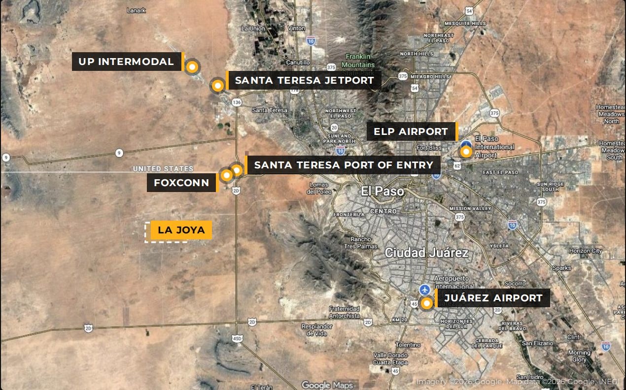
Regional map: La Joya relative to the Santa Teresa port of entry, Foxconn, UP intermodal, the jetport and both airports
Straight-line from the property center: U.S. border 6.5 km · port of entry ~7 mi · Foxconn ~6 mi · Santa Teresa jetport ~12 mi · Union Pacific rail ~13 mi · downtown El Paso ~17 mi · I-10 ~19 mi · Juárez airport ~21 mi · El Paso airport ~24 mi. 2.1 million people across El Paso, Juárez and Las Cruces.
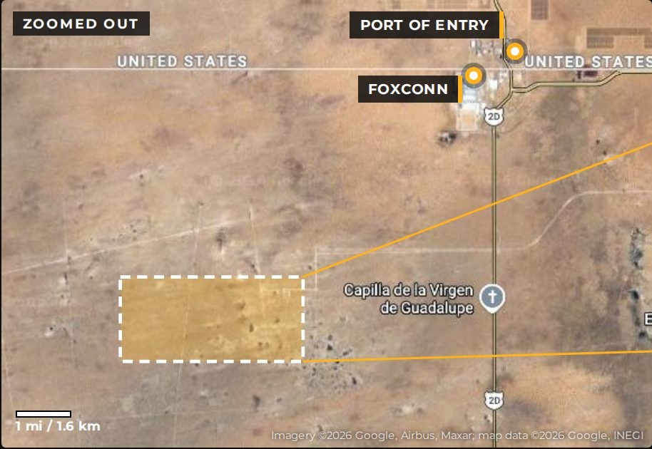
Zoomed-out satellite view showing La Joya relative to the port of entry and Foxconn
Due north to the U.S.: NM-136 reaches I-10 in 12 miles. South to Mexico: the bypass reaches Hwy 45 and Chihuahua, skipping Juárez; Hwy 2 is 7 mi south.
Why Now

Oracle, OpenAI, Foxconn and Union Pacific already bet on this corridor

$165B

Project Jupiter

AI campus for Oracle and OpenAI under construction next door in Santa Teresa — in a state with national labs, White Sands and Spaceport America.

100%

Polo de Desarrollo

Mexico’s federal San Jerónimo development zone (June 2025): immediate 100% ISR deduction on new fixed assets 2025–2030, plus border ISR/IVA rates of 20%/8% through 2026.

$400M

Union Pacific hub

UP’s 2,200-acre Santa Teresa facility is 13 mi away — 55–60 trains a day, direct to the LA/Long Beach ports, with a planned rail crossing at San Jerónimo–Santa Teresa.

+141%

Export growth

Santa Teresa exports grew 141% in 2024; the port generates roughly $2B in economic impact every year and is under expansion study with a new border highway.

1.2M+

Workers

Skilled, cost-competitive workforce in the Juárez area — one of North America’s largest manufacturing regions: 27,000+ jobs and $4.1B invested since 2013.

20×

Bigger than the Polo

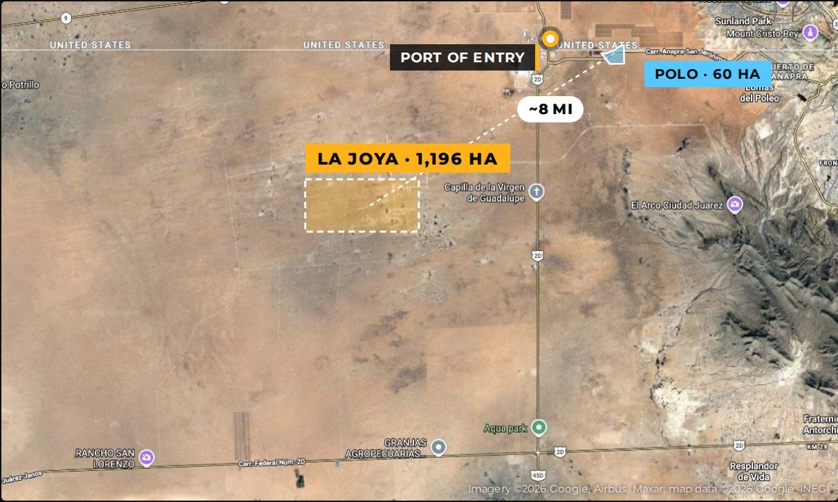
The federal Polo zone is 60 hectares. La Joya is 1,196 — about 20 times larger, in the same corridor. The suppliers and logistics that follow the Polo will need room to grow.
Rail 2030 · Juárez 2040 Plan

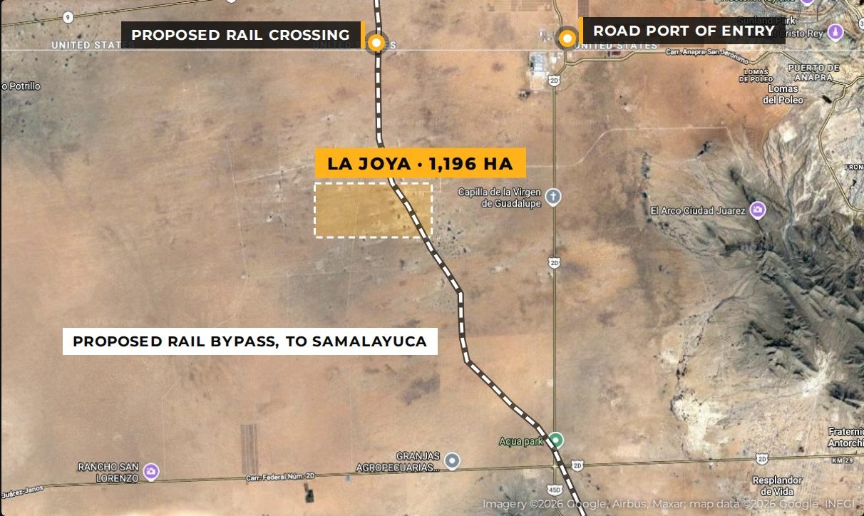
The 2040 plan draws the new border railroad through this land

Map of the proposed Samalayuca-Santa Teresa rail bypass and international rail crossing relative to La Joya
The proposed Samalayuca–Santa Teresa rail bypass (2030) would link Ferromex to Union Pacific and BNSF, with the proposed international rail crossing about 6 km north of La Joya — and the project is registered with Mexico’s Finance Ministry (SHCP) for federal investment. Next door sits Juárez’s 3,503-ha San Jerónimo growth reserve, about twice the size of the 630-ha industrial park — while La Joya itself lies in Ascensión jurisdiction, just outside Juárez’s planning limit and free of its sector master-plan rules. Rail route proposed and traced from PDUS 2040 Map E-04; final alignment and timing subject to the executive project (IMIP / Municipio de Juárez, PDUS 2040, 2024).
The Polo, Mapped

Mexico’s federal bet on this crossing

Map comparing La Joya's 1,196 hectares to the 60-hectare federal Polo de Desarrollo, about 8 miles from the port of entry
Target sectors for the Polo: logistics, automotive, e-mobility, medical devices, industrial innovation and tech services.
Power & Water

The utilities an industrial user asks about first

Water on site: JMAS pumping plant and wells 9 & 10 inside the property. Power: two CFE 115 kV substations within 8 miles (San Jerónimo at 6 mi, Conejos-Médanos at 8 mi), with the 60 MW Kaixo solar plant to the south. Roads: bypass 5 mi east, Hwy 2 7 mi south. Ascensión jurisdiction, next to Juárez’s 2040 growth reserve — near FedEx and the Axial industrial park.

Best suited for: industrial park · cross-border logistics · manufacturing · data center & energy · master-planned development · land bank.
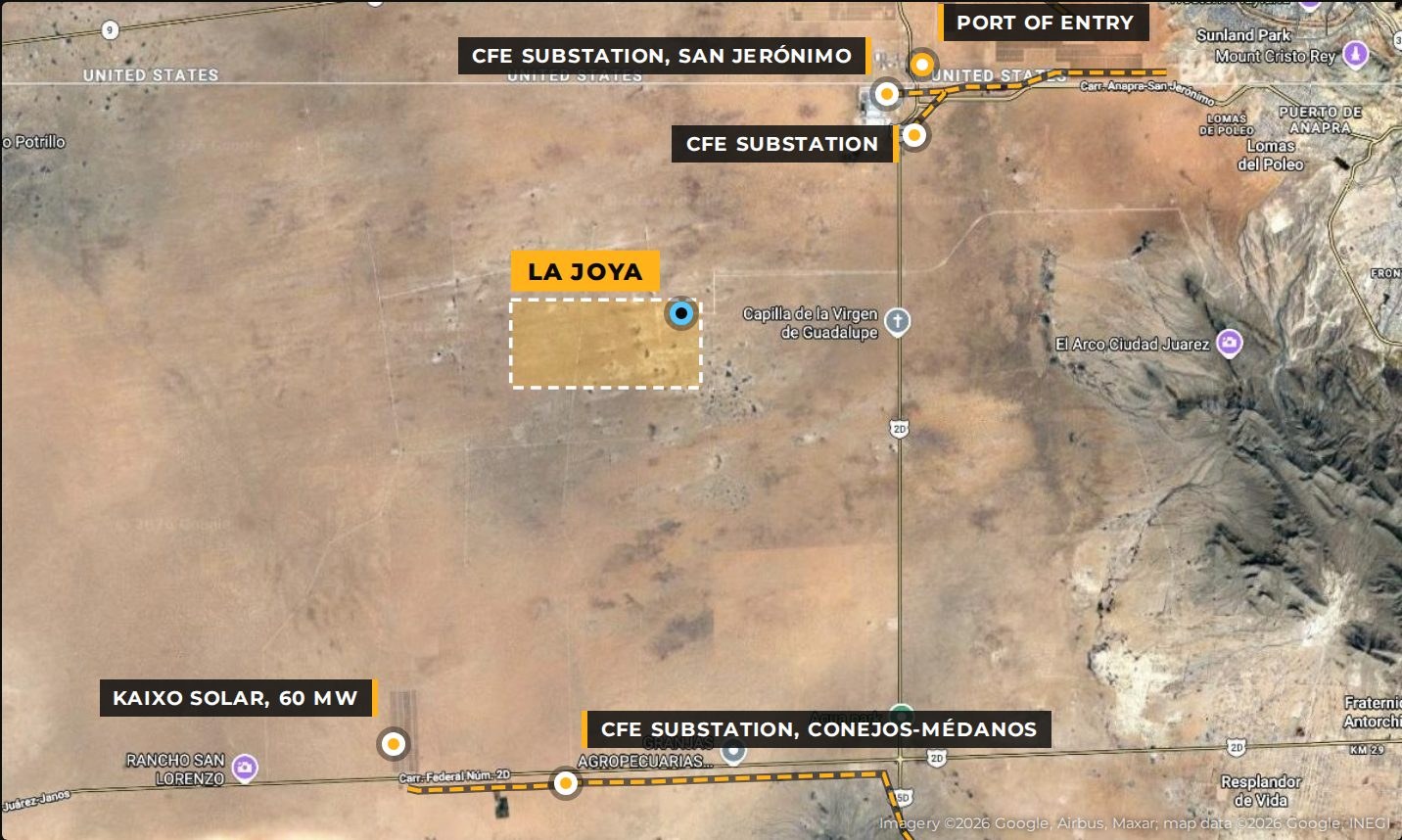
Power and water map: CFE substations, high-voltage lines, Kaixo solar and the on-site JMAS pumping plant around La Joya

Land, water, power, rail and people are in place. The vision is yours.

Pricing on request for qualified buyers. Site tours from El Paso.

Contact Carlos Chávez

Deemed reliable, not guaranteed; buyer to verify acreage, boundaries (approximate), distances (straight-line), utilities and incentives. Sources include owner materials, Federal Reserve Bank of Dallas (2025), NM Border Authority, NMBIA, Borderplex Alliance, State of Chihuahua (2025), Union Pacific, Hon Hai/Foxconn and DOF border decrees (2025–2026).